| P number: | P002967 |
|---|---|
| Old photograph number: | MNS05137 |
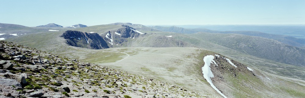
| Caption: | Panoramic view from summit of Cairngorm looking south-west towards Cairn Toul, Braeriach, Lurcher's Crag, Cairn Lochan and Coire an t-Sneachda, Inverness-shire. |
| Description: | Panoramic view from summit of Cairngorm looking south-west towards Cairn Toul, Braeriach, Lurcher's Crag, Cairn Lochan and Coire an t-Sneachda, Inverness-shire. The photograph shows the high summit areas of the Cairngorms, one of accordance of summit tops indicative of a former pre-glacial Mesozoic to Tertiary peneplained land surface that has been considerably modified by glacial erosion. Note the typical development of corries on these northern slopes. To the left is the typical boulder-strewn covering with little vegetation. |
| Date taken: | Sun Jan 01 00:00:00 GMT 1989 |
| Photographer: | Unknown |
| Copyright statement: | Unknown |
| Acknowledgment: | This image was digitized with grant-in-aid from SCRAN the Scottish Cultural Resources Access Network |
| X longitude/easting: | 300440 |
| Y latitude/northing: | 804320 |
| Coordinate reference system, ESPG code: | 27700 (OSGB 1936 / British National Grid) |
| Orientation: | Landscape |
| Size: | 120.65 KB; 1000 x 321 pixels; 85 x 27 mm (print at 300 DPI); 265 x 85 mm (screen at 96 DPI); |
| Average Rating: | Not yet rated |
| Categories: | Best of BGS Images/ Landscapes |
Loading...
Loading...
Reviews
There is currently no feedback