| P number: | P210542 |
|---|---|
| Old photograph number: | A10643 |
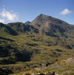
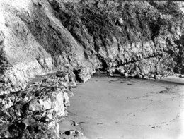
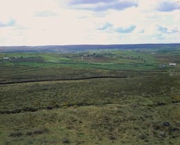
| Caption: | View from field at side of the road between Torrpark and the main Launceston/Camelford road. Looking ENE. |
| Description: | View from field at side of the road between Torrpark and the main Launceston/Camelford road. Looking ENE. Topography in Carboniferous sediments in north Cornwall. The gently undulating productive soil forming the foreground is underlain by soft Carboniferous Slates. The distinct barren ridge in the middle distance shows a faulted outcrop of the Fire Beacon Chert Formation overlying these slates, the faulted junction occurring at approximately the line of trees marking the difference in soil types. |
| Date taken: | Sat Jan 01 00:00:00 GMT 1966 |
| Photographer: | Friend, C.A.F. |
| Copyright statement: | NERC |
| X longitude/easting: | 223500 |
| Y latitude/northing: | 85500 |
| Coordinate reference system, ESPG code: | 27700 (OSGB 1936 / British National Grid) |
| Orientation: | Landscape |
| Size: | 204.34 KB; 1001 x 781 pixels; 85 x 66 mm (print at 300 DPI); 265 x 207 mm (screen at 96 DPI); |
| Average Rating: | Not yet rated |
| Categories: | Unsorted Images |
Loading...
Loading...
Reviews
There is currently no feedback