| P number: | P000473 |
|---|---|
| Old photograph number: | C01884 |
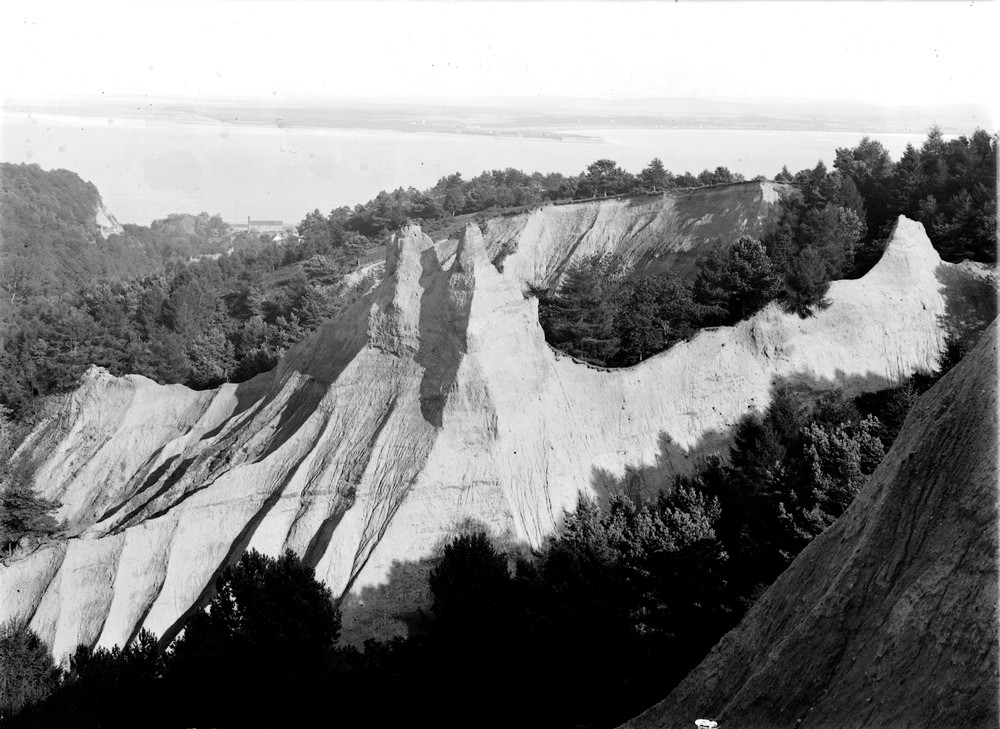
| Caption: | Fairy Glen, The Dens, 1.6 km. north of Fortrose, on the southern side of Rosemarkie Glen. Ross & Cromarty. |
| Description: | Earth pillars are usually developed on the slopes of valleys from spurs and ribs. The slopes of earth pillars usually range from near vertical to about 60 degrees and all usually develop under a cap of resistant material, this may be a boulder, fossil etc. In the case here, the resistant material is the soil and vegetation. The formation of earth pillars by rain wash in the tills that fill an old valley. Photographed about 1910 before the present-day tree cover was established. |
| Date taken: | Wed Jan 01 00:00:00 GMT 1913 |
| Photographer: | Lunn, R. |
| Copyright statement: | Crown |
| Acknowledgment: | This image was digitized with grant-in-aid from SCRAN the Scottish Cultural Resources Access Network |
| X longitude/easting: | 272500 |
| Y latitude/northing: | 858500 |
| Coordinate reference system, ESPG code: | 27700 (OSGB 1936 / British National Grid) |
| Orientation: | Landscape |
| Size: | 211.96 KB; 1000 x 729 pixels; 85 x 62 mm (print at 300 DPI); 265 x 193 mm (screen at 96 DPI); |
| Average Rating: | Not yet rated |
| Categories: | Best of BGS Images/ Images from the archives, Geoscience subjects/ Landforms, glaciation/ Glacial deposits, boulder clay, sand, gravel, Geoscience subjects/ Landforms, weathering/ Earth pillars |
Loading...
Loading...
Reviews
There is currently no feedback