Advanced Search
Advanced Search
0
My Lightbox
Expand view
Log In
Register
Home
Advanced Search
Browse
Lightbox
Map-Based Search
Get Help
Browse by Popularity
Least Viewed Items
Least Viewed Items
P1006702
Diorite. 300 yds E of Meikle Barncleugh.
P1006706
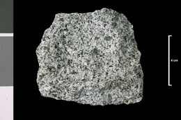
Granite. Field. 800 yds SW of Butterhole.
P1006707
Granite. Field. 830 yds S 30 deg W of...
P1006744
Microgranite. 360 yds SSE of Butterhole.
P1006762
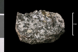
Diorite (altered). Benbrack Hill, 7.25...
P1006842
Cementstone, stained. Lower...
P1006843
Cementstone, stained. Lower...
P1006846
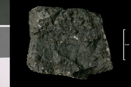
Basalt. Lava, ?Trias. Burn, near...
P1006847
Basalt. Lava, ?Trias. Burn, near...
P1006848
Basalt. Lava, ?Trias. Burn, near...
P1006923
Kilkivan Quarry, Machrihanish. .
P1007041
Ironstone. Monktonhill borehole...
P1007099
Railway cutting (west end), 200 yds NE...
P1007102
In burn, 0.5 mile E 15 deg S of S end...
P1007105
Quarry, Craigs of Kyle, 1.25 miles WNW...
P1007107
Howmuir, 500 yds N of Trees Farm, which...
P1007113
120 yds S by W of E 4776 - E 4778, c....
P1007121
Porphyrite. Dyke, 12 ft wide. In small...
P1007126
Porphyrite. Dyke. Craigs of Bahoun,...
P1007128
Margin of granite. Currie Rig (on 6...
P1007131
Hypersthene porphyrite. Old quarry, W...
P1007132
Hypersthene porphyrite. Old quarry, N...
P1007134
Plagiophyre. Quarry, S of Knockmill.
P1007137
At Knockgardner [farmhouse]. Upper Old...
P1007138
At Knockgardner [farmhouse]. Upper Old...
P1007141
Porphyrite. Tairlaw Burn, 600 yds above...
P1007148
Barracks Bridge. Upper Old Red Sandstone.
P1007150
Dyrock Burn, 0.5 mile above...
P1007167
Agglomerate with sandy matrix. Vent of...
P1007174
Calcified plant stems. From John Smith...
P1007178
Shore cliffs, near bend in road, below...
P1007184
Cliffs, S of heads of Ayr. Lava, Lower...
P1007185
Cliffs, S of heads of Ayr. Lava, Lower...
P1007194
Quartz-dolerite. Lower Old Red...
P1007205
Auchenroy Hill, Grimmet, W of...
P1007207
Auchenroy Hill, near Glenhead,...
P1007209
Sediment, baked. Lower Old Red...
P1007210
Ashy sediment (grit). Tuff, Lower Old...
P1007211
Shore, Greenan Castle, 2 miles SW of...
P1007212
Sandstone, purple. Coal Measures....
P1007213
Sandstone, micaceous, purple, faky....
P1007214
Shale, micaceous, purple. Coal...
P1007216
Sandstone, purple. Coal Measures....
P1007217
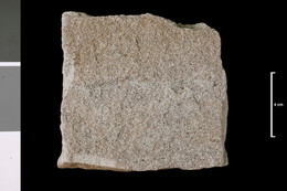
Sandstone, pink to white. Coal...
P1007218
Sandstone, pink to white. Coal...
P1007231
Dolerite with quartz. Sill, post-Coal...
P1007233
Dolerite. Dyke. Kilachie Glen,...
P1007236
Auchinweet Bore [NS423NE/4], no depth...
P1007238
Faky sandstone. Barony Pit Shaft...
P1007241
Honestone: 'Tam o'Shanter Stone'. Used...
P1007242
Shale: potential honestone. Baked by...
P1007243
Shale: potential honestone. Baked by...
P1007362
Trachyte. Mass; Lower Carboniferous....
P1007363
?Limestone [?block in vent]. Lower...
P1007364
Vent agglomerate, including lapilli...
P1007366
Dolerite, Markle type. Plug in big...
P1007368
Felstone. Dyke. At Elygrain,...
P1007369
Felstone. Plug. NE end of Nether Law,...
P1007370
Dolerite. Dyke. Millstone Edge,...
P1007371
Doleite. Dyke. At Mosspaul Inn,...